On this page:
Overview
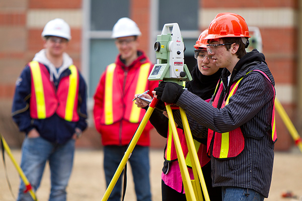
The Geomatics Engineering Technology program offers practical skills and a comprehensive theoretical foundation in geomatics, enabling you to master the collection, analysis, and application of spatial data.
Through hands-on learning with graphic information systems (GIS), global positioning systems (GPS), and remote sensing, you’ll learn to map and interpret the environment, supporting fields like urban planning and environmental monitoring.
In this program, you will learn:
- land surveying methods to precisely determine point locations and measure distances/angles on earth
- remote sensing techniques for information gathering using satellite and aerial sensors
- cartography, which is the practice of mapmaking and illustrating spatial links between features
- how to use GIS for the management and presentation of geographic data
- how to use global navigation satellite systems (GNSS) and GPS technologies for global geo-spatial positioning
- how to use photogrammetry for precise measurements of areas
- geography by analyzing spatial patterns and human-environment interactions
- how to create a digital map and use it for interactive analysis.
Possible career paths available once you graduate include surveying, mapping technology, energy, civil engineering, GIS, government roles, and engineering technologist jobs. This two-year diploma consists of four 15-week semesters, with intakes every September.
If you are skilled in math, comfortable with technology, collaborative, communicative, and an outdoor enthusiast, this SAIT program is for you.
Those in the geomatics engineering technology field are objective, innovative and directive.
You need:
- math skills
- the ability to think logically and critically
- the ability to study spatial problems and measurements
- problem-solving skills
- speaking and listening skills
- the ability to work as part of a multidisciplinary team.
You should enjoy working outdoors, analyzing information to find innovative solutions to problems, and taking a step-by-step approach to your work.
The opportunity to advance your education by transferring into this program or gain credit for previous postsecondary courses may be available.
There may also be opportunities to further your education once you graduate.
Learn more about program and institution transfer options.
During your final semester, you’ll complete a capstone project where you’ll perform research, analysis, drafting and editing to create a formal report. You’ll then present your report to instructors, other students and industry guests.
This program is nationally accredited by Technology Accreditation Canada at the technologist level.
Graduates are eligible for certification by the Alberta Society of Surveying and Mapping Technologies (ASSMT) and the Association of Science and Engineering Technology Professionals in Alberta (ASET).
After successfully completing this program, you’ll be awarded a SAIT Geomatics Engineering Technology diploma.
Careers and opportunities
Each year, SAIT conducts a survey between February and April to determine the employment rate, salary and satisfaction of our newest SAIT alumni.
![]() 100% graduate employment rate
100% graduate employment rate
![]() $72,000 average starting salary
$72,000 average starting salary
Find out more about our graduate employment statistics >
Our graduates may work in the following occupations. Some careers require additional experience and education.
Associated National Occupational Classification (NOC) codes: 22213, 21202, 21203, 22214.

Career counselling and support
Unsure which career path is for you? SAIT offers career planning services to help you decide your future.
You can also get started by taking our online career finder quiz, which can help you narrow down your search based on your current skills and interests.
Finally, you can also head to Alberta alis for various tools and resources, including additional quizzes and labour market information to help you narrow down a career path.
Services and workshopsCourses
The Geomatics Engineering Technology diploma requires 60 credits (20 courses) to complete.
The program spans two years, with two semesters in year one and two semesters in year two.
| Course | Credits |
|---|---|
|
This course examines geomatics engineering theory and design, emphasizing construction and municipal surveying methods. It will cover the organization and management of survey data in a three-dimensional environment for building and analyzing surfaces, modelling road corridors, developing legal plans and performing grading and volume calculation tasks. It also covers various techniques for rendering, visualization, animation and presentation of geomatics data. Pre-requisites:
|
3 |
|
This course is designed to develop technical writing and presentation skills to ensure workplace readiness. Students will learn how to evaluate communication situations, analyze documents, assess research sources and develop organizational skills to apply in their work. They will learn about and practice designing, formatting and writing various professional documents. Students will also develop confidence (through practice) in developing and delivering effective and engaging presentations. |
3 |
|
This practical course on computer functionality and commonly used industry software covers current productivity software to develop industry-specific solutions in communication and organization, documentation, data management, analysis, and visualization. Other topics include file management techniques and best practices, security considerations such as identifying threats, safeguarding data and intellectual property and digital citizenship and etiquette are also included. Equivalents:
|
3 |
|
Geomatics Drafting is a computer-aided survey design and drafting course using survey field notes, registered plan documents and other geomatics data to construct survey plans, topographical maps, property reports and subdivision layouts. This course will familiarize the student with geometric construction and orthographic projections in a 2D and 3D CADD environment. |
3 |
|
This course introduces map and plan reading, research methods and algorithm design for visualization of spatial data. Map reading incorporates scale, coordinate systems, contouring methods, generalization of data, and the interpretation of colour, symbols, and labels for effective communication. Examples of surveying and engineering plans are used to locate land parcels and interpret natural and artificial features that affect development and construction projects. Remotely sensed imagery, including aerial photographs, develop perspective, scale and geometry concepts. Research methods, validation of information sources, locating maps and spatial data, and locating survey plans prepare participants for future projects. Basic algorithm design concepts are introduced to analyze engineering problems and create algorithms. |
3 |
|
The course introduces the concepts of geodesy and map projections and their implementation in different Geomatics applications. Topics will include physical and mathematical representations of the Earth’s surface, Earth’s gravity field, principles of physical geodesy, height systems, ellipsoidal geometry, geodetic reference systems, terrestrial and celestial coordinate systems, Three dimensional (3D) coordinate transformations, time systems, astronomic positioning, elements of map projections, classes and types of map projections and the calculation of mapping grid coordinates from geodetic curvilinear coordinates. Pre-requisites:
Equivalents:
|
3 |
|
This course focuses on geospatial data management, analysis and representation and production with applications and techniques used during all stages of the Geographic Information System (GIS) development cycle. Topics include database design principles and management, database linking, data classification and analytical processes such as spatial queries, topologies, spatial joins and map presentation. Pre-requisites:
|
3 |
|
This course introduces the concepts and applications of three-dimensional modelling using terrestrial and airborne laser scanning methods. The course expands on the technological limitations of laser scanning and how the limitations are overcome with technology integration. There is an in-depth investigation of data collection and processing laser scanning data. The topics include terrestrial laser scans in the field, visualization, organization, registration and calibration of laser data, feature extraction, quality assurance and presentation of laser scanning results. Pre-requisites:
|
3 |
|
This course is an introduction to the science of photogrammetry and the process of planning for an aerial image and LiDAR acquisition project. Students will build on previous Geomatics knowledge to plan a mapping project, complete an orthorectified photograph of the SAIT campus and create three-dimensional models from stereo imagery. Pre-requisites:
|
3 |
|
This course enables students to apply basic algebra and introductory calculus knowledge to resolve applied scientific and technological problems. Applications include linear motion, areas under curves, and volumes of revolution. Equivalents:
|
3 |
|
This course enables students to apply advanced algebra, integral and differential calculus methodologies to scientific and technological applications. Topics include trigonometric and transcendental calculus, methods of integration, specifically integration by parts, trigonometric substitution and tables. Applications include linear motion, areas under curves, volumes of revolution, centroids, moments of inertia, and program-relevant applications. Pre-requisites:
Equivalents:
|
3 |
|
This course focuses on the capstone project, from defining the situation for investigation through research, data collection, data analysis, drafting, editing, and producing a formal report. Written proposals and progress reports are included. The project is presented orally to faculty, peers and industry guests. The report topic is specific to geomatics technology. Pre-requisites:
|
3 |
|
Introduction to survey theory and field practice. A brief history of surveying and current applications. Focus on using, caring and handling equipment while implementing safe work practices. Demonstrate skills of observation, record-keeping and problem-solving. Recognize concepts of error theory concerning measurements of elevations, distances and angles. Calculate conversion of units, angles and directions, and polar and rectangular coordinates. Calculate positions, survey closures and adjustments. Apply trigonometric concepts to calculating intersections, areas and land partitioning problems. Field exercises use industry-standard equipment to conduct typical construction surveys, ensuring participants experience a range of environments while demonstrating practical survey skills. |
3 |
|
A comprehensive introduction to Global Navigation Satellite Systems (GNSS) technologies focusing on the Global Positioning System (GPS). Satellite system concepts, design, operation, implementation, and applications are described, and detailed information on GNSS signal, satellite status, plans, schedule, and capabilities are discussed. GNSS theory is applied by planning, collecting, and analyzing field data. Surveys are performed using single point and differential positioning real-time and post-processed kinematic and static surveying methods. Pre-requisites:
|
3 |
|
Demonstrate field survey techniques using conventional equipment. Employ data collection and desktop survey software. Demonstrate project management for planning, field data capture and layout, and production of deliverables. Conduct topographic surveys, engineering layout, earthworks surveys and legal surveys. Calculate horizontal curves from tangents and vertical curves from constant grades for design and layout. Pre-requisites:
|
3 |
|
Theory of errors, analysis of errors and reliability measures of Geomatics data, implementation of error propagation in different Geomatics applications, pre-analysis for Geomatics projects, formulation of direct, indirect, conditional and implicit models for Geomatics problems, application of parametric, conditional and combined least-squares estimation techniques for adjustment of Geomatics measurements, linear and non-linear least-squares estimation with iterative solutions, introduction to univariate and multivariate statistics, estimation of unknowns with weighted observations, quality assessment of the adjustment results, error ellipses, percent errors, advanced least-squares estimation techniques applied in Geomatics such as Kalman filtering and sequential solution methods. Pre-requisites:
Equivalents:
|
3 |
|
Introduction to control survey concepts, definitions and implementation in geomatics applications. Pre-requisites:
|
3 |
|
This course introduces the concepts of electromagnetic energy and how it is applied to create remotely sensed images. Digital image processing from all remote sensing platforms is investigated in how information is extracted from a single or multiple exposure(s). The topics include image acquisition, manipulation, rectification, enhancement, classification and emphasizing hands-on image processing. Pre-requisites:
|
3 |
|
This course introduces the concepts of several surveying applications and their implementation in Geomatics. Topics will include sewers and storm water drainage systems, hydrographic surveying, subdivision surveys, well site surveys, seismic surveys, tunnel and mining surveys, inertial navigation systems, multi-sensor integration and data fusion for navigation and georeferencing of remotely sensed data. |
3 |
|
This course introduces the law and practice of land surveying in Western Canada. Land ownership, land registration systems and the documents registered against parcels are studied to provide a basis for locating land, determining boundaries and identifying any land-use restrictions. The DLS/ATS survey system provides the foundation for subdivisions of both public and private lands. It determines the positions of boundaries and improvements in rural and undeveloped areas. Best practices for boundary determination are applied to subdivision and real property surveys in urban areas and to well site and right-of-way surveys in rural and undeveloped areas. In addition to studying artificial boundaries, the physical identification and legal context for natural boundaries are also explored. Pre-requisites:
Equivalents:
|
3 |
Progression
Students must attain a PGPA and/or a CGPA of 2.0 or better in each semester and pass the necessary prerequisite courses to progress through the program. To qualify for graduation, students must pass all courses, attain a CGPA of 2.0 or better and complete course requirements within the prescribed timelines.
Review our grading and progression procedure >

Explore your options!
Some courses in this program are available through Open Studies. You can complete courses via Open Studies to get a head start on your education, reduce your course load once accepted into a credentialed program, or determine which career path best suits you before you fully commit.
You may also take courses for general interest or personal and professional development.
Available Open Studies coursesAdmission requirements
Applicants educated in Canada
All applicants must demonstrate English language proficiency and meet the following requirements or equivalents.
- at least 50% in Math 30-1 or at least 70% in Math 30-2
- at least 50% in English Language Arts 30-1 or English Language Arts 30-2
- at least 50% in Science 30 or Physics 20.
SAIT accepts high school course equivalents for admission for applicants educated outside Alberta.
All applicants who were educated outside of Canada must demonstrate English Language proficiency and provide proof they meet the program admission requirements with an international document assessment. Find out what educational documents are accepted and assessment options.
SAIT may also accept courses completed at certain international post-secondary institutions.

Academic Upgrading
Missing an admission requirement for this program? Upgrade your prior education to help you receive admission into one of SAIT's career programs.
Upgrade
English language proficiency
All applicants must demonstrate English language proficiency prior to admission, including students educated in Canada.
Learn moreAvailable intakes
Fall 2024
Start dates:
- Domestic students: Open
-
-
Application deadline: June 28, 2024
-
- International students: Closed
-
-
Application deadline: May 29, 2024
-
Costs
2024/25 tuition and fees
The following costs are effective as of July 1, 2024.
Domestic students
Books and supplies are approximately $1,000 - $1,500 per full-time year.
This is a bring-your-own-device program with a standard computer hardware and software requirement. See the specific requirements on our computers and laptops page.
Find your booklist on the SAIT Bookstore's website. The booklist will be available closer to the program start date.
Can't find your program or course? The bookstore didn't receive a textbook list. Contact your program directly to determine if they're still refining course details or if you're in luck; no textbook purchase is required this term.
2023/24 tuition and fees
The following costs are effective until June 30, 2024.
Domestic students

Financial aid
Paying for your education may feel overwhelming, but we have resources and programs that can help, including information about payment options, student loans, grants and scholarships.
Learn moreApplication process
Ready to apply?
Follow our step-by-step guide to submitting a successful application.
Communication during admission
Email is the primary source of communication during the selection process. Ensure your personal email account is managed appropriately to receive our emails, files and communications. We recommend you add the construction.advising@sait.ca domain to your safe senders' list or you risk missing critical email messages.

Begin your application
Apply now using the online application portal.
Ensure you have a valid Visa or Mastercard to pay the non-refundable application fee of $120 for domestic applicants or $150 for international applicants.
Apply nowInformation sessions
Prepare for a strong start in your chosen program or get the details you need to decide your future path.
Our expert staff and faculty are ready to answer your questions and provide information about the following:
- What sets SAIT apart
- An introduction to the program and area of study
- Admission requirements
- Future career paths
- Information on the earning potential and graduate employment rates.
Contact us
Prepare for a strong start and get the details you need to make a decision about your future. Our expert staff and faculty are ready to answer your questions, and provide information about:
School of Construction Advising
-
Phone - 403.284.8367
International Student Advising
-
Phone - 403.284.8852
-
Email - international@sait.ca
Other programs you may be interested in
Study to be a geographic systems (GIS) technologist, technician or analyst for a range of industries, from forestry and natural resource exploration to government.
- Program length:
- 2 years
- Location:
- In person (Main Campus) or Online
- Faculty:
- School of Construction

Study to virtually design buildings, roads, bridges and other infrastructure projects through hands-on civil engineering technology courses.
- Program length:
- 2 years
- Location:
- In person (Main Campus) or Blended (Main Campus and Online)
- Faculty:
- School of Construction

Become an accredited mechanical engineering technologist specializing in design and development.
- Program length:
- 2 - 3 years
- Location:
- In person (Main Campus)
- Faculty:
- School of Manufacturing & Automation

Subscribe for updates
Your journey starts here! Sign up to get important updates on:
- Construction, transportation and manufacturing programs
- Application information
- Relevant news and events